Tuesday, December 29, 2009
New cruising friends!
After a few days at anchor in the La Paz channel, we moved into the dock at Marina de La Paz and connected with new friends from Portland, Pete and Rose Ann Thomsen, who were spending a week or so on Talion, Patsy Verhoeven's Gulf Star 50. We did some hiking, and dinghied over to the Mogote, a large sand spit north of the marina and anchorage. A fellow sailor from New Zealand had careened his boat on the ebb tide and was waiting for it to lean over further as the tide receded so he could climb in the water and clean the bottom. It's a bit more complicated than diving and scrubbing the bottom and definitely more work than hiring a diver to do it for you!
Friday, December 25, 2009
Christmas Dinner
The gentleman in the Scottish tam is an accomplished ukelele player and quite a good friend.
Chris Bennett and his fiance, Rani, introduced us to Jo and Rob from Blue Moon and Randy and Gina from Balena. We shared Christmas dinner with them at the Singlar Marina, a two mile hike west of the marina where we are staying...excellent food, good company, lots of laughter and a bit of music.
Friday, December 11, 2009
Effects of Hurricane Jimena
Blue sky: San Juanico December 2009
Cloudy sky: San Juanico December 2008
The same spot.
Last December, we kayaked into the estuary from the bay, finding egrets, cormorants, and pelicans as we passed by.
This year, a 10-foot high berm has closed the entrance, extending the beach all the way to the crags and shutting off the estuary, now a salt-lagoon drying in the sun.
What happened as the year passed? One major meteorological event was Hurricane Jimena which came through this area at the end of August/first part of September 2009. The wind, waves, rain, and floods could have all contributed to the shifting sands of this remote beach. It would have been fascinating to have been on the spot to see the change!
Back to the Baja -- San Juanico
From the boat, we dinghied into shore and hiked up to a geocache on a ridge just above the north anchorage. Many thanks to the crew from Don Quixote for putting the cache in a sturdy plastic container and under a well-camouflaged pile of rocks!
From the cache, we descended to one of several roads that wind through these hills. Some lead to recently built homes; the one we took wandered south to private property with one small house and a corral, unoccupied. There is evidence of visions of future development--rough roads, cleared spots that overlook the sea (the perfect place for a house). The views are amazing, as this shot of boats at anchor illustrate. Odyssey is the one in the middle. We walked for a couple of hours, then turned around, leaving the miles of road further south for someone else to explore.
Wednesday, December 9, 2009
Bahia Algondones again
Shrimp boats (camaroneros) on the Sea of Cortez are big and colorful. We've noticed one fleet is centered in the waters north of San Carlos, south of Kino Bay. They tend to anchor in "shallow" (40-80 feet deep) water during the day and go out into deep water at night, but we often see them motoring back and forth from Guaymas. These two graced the north part of Algodones Bay as we set out on our crossing to San Juanico from Marina Real (San Carlos). There were several more just outside the entrance to the Bay.
I don't think they feel the choppy waves as much as we do. It seems that the waters around San Carlos are often turbulent, confused seas, tossing and tumbling us, giving us a bit of a rough start to the trip across the sea. Marv was sick, I had taken some Bonine, so felt bad but not THAT bad!
We left at noon on Wednesday and, after a night cork-screwing through 3-5 foot swells (with an occasional 8-footer thrown in) and 12-20 knot winds, we arrived safely in Caleta San Juanico, putting down the anchor at 7:30 AM Thursday.
Friday, November 27, 2009
Thanksgiving in Seattle
For over 30 years, we have been getting together with friends and family in Seattle, San Francisco, or Portland (it all started in Walla Walla, Washington in 1975) to share the long Thanksgiving weekend. This year, Paul Fitzgerald and Linda Peterson hosted the group in Seattle, where the weather was spectacular...one day of misty rain, the next of crystal clear skies and magnificent views of the Olympic Mountains from their back deck.
The event is a well-orchestrated symphony of rolling dolmas, stuffing turkey, baking pies, saute-ing vegetables, eating snacks, sipping drinks, kneading bread, giving timely advice on how to carve, and, of course, sharing the meal. Everyone brings a special dish, with its special flavor, to the table.
The rest of weekend is spent hiking, walking, jogging around Green Lake, talking, laughing, watching movies, reading, Geo-caching, visiting other friends in Seattle... Thanksgiving is a favorite holiday...there is so much to be thankful for.
Saturday, November 21, 2009
Bahia Algodones
Just a few kilometers northwest of the small town of San Carlos, Sonora, is the beautiful bay of Algodones (Cotton Bay). It's one of our favorite anchorages, wide, picturesque, and accessible. You can anchor on the north end if there is a northerly blowing, or on the south end to avoid winds from the south. Usually the swells bypass the entrance to the bay, but if they are directly from the northwest, it can be a bit rolly at anchor.
The peak, Tetakawi, rises high above the bay to the south.
On the little islet above our anchorage, Marv, geocacher extraordinaire, signs into the logbook (www.geocaching.com)
At the far north end of the bay, a small lagoon is surrounded by condominiums, evidence of the large North American community here and in San Carlos.
Tuesday, November 17, 2009
Baja Wildlife at Puerto Don Juan
All those coyotes that we hear barking at dusk and see trotting along the beaches in search of breakfast have to live somewhere!
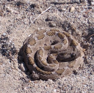
Marv flipped over a sheet of fiberglass debris on the beach to find this small rattlesnake. It didn't move as we approached, flicking its tongue to test the air around. We didn't push our advantage.
Sunday, November 15, 2009
Hiking above Puerto Don Juan
The Sea of Cortez is very big and it looks bigger from the hilltops around it. In this photo, we are looking north into the anchorage of Puerto Don Juan. In the left foreground is a narrow rocky ridge that connects the hill in front of us to the Baja. (There is question as to whether this ridge is natural or was built to attach the island to the peninsula. Or could it be a combination of the two: naturally low land, exposed at low tide, added to by nature AND people to solidify the connection?). Beyond the anchorage, Islas Cabeza de Caballo, Ventana, and Coronado line up, stepwise to the north. Out of sight are Los Gemelos (to our left) and Isla Angel de la Guarda (to the right).
Mike Godsil and Ardy Dunn resting before the descent.
Saturday, November 14, 2009
Village of Bahia de Los Angeles
Bahia de Los Angeles is a bit remote by auto. You go 480 kilometers south of Ensenada on Highway 1 and then 66 kilometers further off the road to the bay which sits on the east side of the Baja Peninsula, protected from the Sea of Cortez by several islands: Coronado (Crown), Ventana (Window), Cabeza de Caballo (Horse's Head), and Los Gemelos (The Twins). Further east, across the Canal de las Ballenas (Whale Channel) lies the large Isla Angel de la Guarda (Guardian Angel Island).
There is a large North American presence in the village as many "ex-pats" have settled here, it is a favorite spot with cruisers who spend the summer in the Sea of Cortez (not as hot as sites further south), sports fisherman make it a launching point into the Sea, and there are various ecotourist activities.
We were impressed with the public art work, the small natural history museum, the clean village streets, and a lengthy conversation with a police officer at the local "Delegacion del Muncipio" who told us a bit about the history and plans for the area (it was first settled by European missionaries in 1746).
Friday, November 13, 2009
Development in the Baja
A Mexican family has purchased the beach front at Playa Pescador and is renovating the dozen little cabanas that are there. They are also having new palapas and one small house built. There are no roads into the area, so all the equipment and materials comes by launch. There is a bustle and busy-ness here, and we talked for a few minutes with the workers on site, who were welcoming and informative.
Thursday, November 12, 2009
Puerto Don Juan
From our anchorage at Las Cruces on the Southwest corner of Isla Tiburon the sea looked calm and inviting. Once out in the channel between Islas Esteban and Tiburon, however, the 25 knot NNW winds and 4-foot swell made for uncomfortable going. We turned around and re-anchored for another night before heading north.
Our destination--Puerto Don Juan and a rendezvous with fellow Portland Rose City Yacht Club members, Delphi and Mike Godsil on sailing vessel Trig.
We had two days of respite from the wind, during which we kayaked around the bay, hiked to Bahia Pescador in the larger Bahia de las Animas and motored a bit further north into the Bahia de los Angeles where we spent a rolly, windy night. The next morning we had the chance to practice "how to untangle 3/8 inch anchor chain from the anchor while the wind is blowing 20 knots and you are drifting" (fortunately, the wind was blowing us offshore, not on!). Mike and Delphi stood by until we had things clear on the foredeck and were underway. Many thanks to them!
Puerto Don Juan is not a port. It is considered a "hurricane hole," a place to find shelter from high winds and heavy seas. But there is no development here, just coyotes calling at night from the hillsides, pelicans and cormorants sunning themselves on jagged reefs, osprey perched on cactus, vultures circling above, and snakes and lizards tucked into rocks and arroyos.
Monday, November 9, 2009
Bahia Los Perros on Isla Tiburon
Bahia Los Perros (Dog Bay) was our first anchorage on Isla Tiburon. A dinghy ride to shore gave us the opportunity to hike up one of the nearby hills, from which we had a great view of the entire south end of the island.
On the way back to the boat, we passed over what we thought was a rock bed, probably a hundred yards in diameter. Actually a school of fish, it was so closely packed together that it totally obscured the sandy bottom. There was a good reason for all those pelicans perched on the rocks and reefs around the bay!
Saturday, November 7, 2009
Baby Turtles?
Sea turtles come ashore on the beaches of Mexican mainland to lay their eggs, the Olive Ridley and Kemp's Ridley being the most common. When the babies hatch, they have about 24 hours to make it to the sea for safety. By instinct, they have to find the right direction, then run the gauntlet of debris, animals (coyotes, snakes, etc) and sea birds (mostly gulls, gannets, and pelicans) to reach the surf. In the water, birds still hunt them, and they are prey to larger animals and fish. They are caught in fishing nets and die. On small beaches like the one in Bahia San Pedro, only about 10% of the babies make it to the sea, and, overall, about 1% of all sea turtles hatched survive to become adults (http://www.vallartasource.com/eco_turtle.php).
We were not there on the full moon when these babies set out on their journey, but saw evidence of their tracks on the beach.
Monday, November 2, 2009
Back in San Carlos
The sun is hot, the days are bright, mosquitoes come out at night, and the boat keeps us busy preparing for another season on the Sea of Cortez.
We arrived in San Carlos on October 28 and are staying in a condo at Marinaterra (thanks Jack and Joanne!). We hope to put the boat in the water tomorrow or Wednesday and will go north for a couple of weeks, then back to San Carlos where we will tie the boat up in the marina, drive to Phoenix and fly to Seattle for Thanksgiving with the friends we have shared the holiday with for over thirty years.
What to say? It is hard to leave family and friends back home. As you know from previous blogs, we are proud new grandparents of a charming little girl. But you may not know that two of our dear friends died this summer; young, sorely missed.
We are reminded of the cycle of life that, on a daily basis, we see with the rise and fall of tides, sun and moon; and that is evident, from a more distant lens, in the growth of children, the success of young athletes, the languages learned and pictures painted, the mirror image that, more wrinkled and grey, greets us each morning.
Who knows what adventures this sea will bring...we are blessed that you are here with us.
Saturday, October 17, 2009
Tuesday, October 6, 2009
It's a girl!
She arrived this morning at 10:38. Weighing in at 7# 10oz and measuring 20 inches in length, she is a miniature of her big brother, Miles, except for her gender, her ears, and her nose (a gift from Liz). What a beauty!
Everyone is well, and not nearly as tired as Philip appears in this photo. They are, however, as excited as Miles looks...or even moreso.
Wednesday, August 12, 2009
Isn't this a sailing blog?
Malcolm and Philip recently marked their 20th year high school reunion (where DID the time go?!?) and came to visit us and attend the Lincoln HS reunion in Portland, OR. Grandson, Miles, enjoyed the visit, mostly playing with puzzles, toys and paints. Among other activities were hiking with Nana, collecting apples from a local tree, making applesauce, helping water the gardens, and making sure the birds had a clean bath ready each morning. He's a big help in the kitchen and shows promise of being a fine gardener, just like his dad!
Sunday, August 9, 2009
Tuesday, June 30, 2009
Happy Birthday, Miles
Wednesday, June 17, 2009
Back at the Gate
Saturday, June 6, 2009
In Batopilas
Ardy crossing the plank bridge over the Batopilas River. We had just visited the old Hacienda, a mansion built by Alexander Robey Shepherd (from Washington DC, who made a fortune in silver mining) in 1875, now gone to ruins.
From the cool, crisp, pine-scented air and the lakes and forests of Creel, we meandered down into semi-tropical heat, thick vegetation, dripping water, and cockroaches bigger than the ones we met in New Orleans years ago.
One of the oldest buildings in town houses a store, as it has from when first built; just off the main plaza, it is a landmark of sorts.
Batopilas has a history as a mining site, the museum explained the role of Spaniards in building it up...and the decline that has occurred since the mines have closed. An aged aqueduct still serves agriculture in the area. Mangoes were in season, but papaya, oranges, limes, and other tropical fruit are abundant.
Today, the town deals with concerns of every Mexican town...here is the center for Family and Infant Development (DIF)
Friday, June 5, 2009
Road to Batopilas
A trip to the Copper Canyon isn't complete without going down to the bottom of one of the barrancas. A popular trip is to Batopilas, about 140 kilometers (four hours) down a winding, narrow, and, in parts, under construction road. The edges are unprotected, the bus sways over on the curves, and your breath is taken away when you look straight down for a thousand feet. Marv claims he's more comfortable (and probably safer) in seas with 12-foot high waves.
Subscribe to:
Posts (Atom)